Snow, Ice, and Cold Abound As Major Winter Storm Continues
This morning finds a significant longwave trough digging into the south-central United States.
In the wake of the trough, effectively uninterrupted northerly flow is allowing arctic air to spill south through the central US. The result has been a much-anticipated surge of frigid temperatures on the tail end of climatology, breaking dozens of daily records and bringing sub-zero wind chills to the Gulf coast.
For some parts of the country, the cold is quite dangerous, bringing the potential for property damage and human health impacts to areas that typically see mild winters. This is exacerbated by power grid issues at the junction of storm damage, demand surges, and supply limitations. For many in the south-central US, the bulk of the ‘storm’ has passed, but the incredible cold will continue introducing major weather-related impacts.
The storm itself, meanwhile, is shifting its focus towards the eastern third of the US.
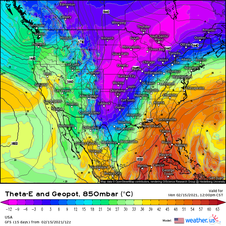
The aforementioned trough is now producing a great deal of divergence aloft over the north-central Gulf and the states nearby, which coincides with an impressive temperature gradient between a warm Gulf airmass and the frigid continental air streaming south. Along this boundary, the development of a moisture-laden surface low is underway. Fanning towards the north is the low pressure aloft, meanwhile, with an 850mb cyclone centered over Memphis.
The result is two-pronged: first of all, it introduces an incentive for lift well inland of the surface low center over the Gulf waters, which is allowing precipitation to fall. Secondarily, the introduction of a warm sector aloft deep into the midst of a frigid arctic airmass is allowing a variety of winter weather to fall.
To the north/northwest of the warm front around this level, near the Mississippi river now, temperatures are cold throughout the atmosphere, and moderate to heavy snow is falling as Gulf moisture streams north and interacts with low to mid level forcing for ascent.
To the south of the warm front aloft but to the north of the surface warm front, meanwhile, moderate freezing rain is falling, as precipitation melts in the surging Gulf airmass before freezing on contact with the surface.
Each of these wintry precipitation types will continue spreading northeast with the system at large, bringing significant impacts from persistent ice and snow to many.
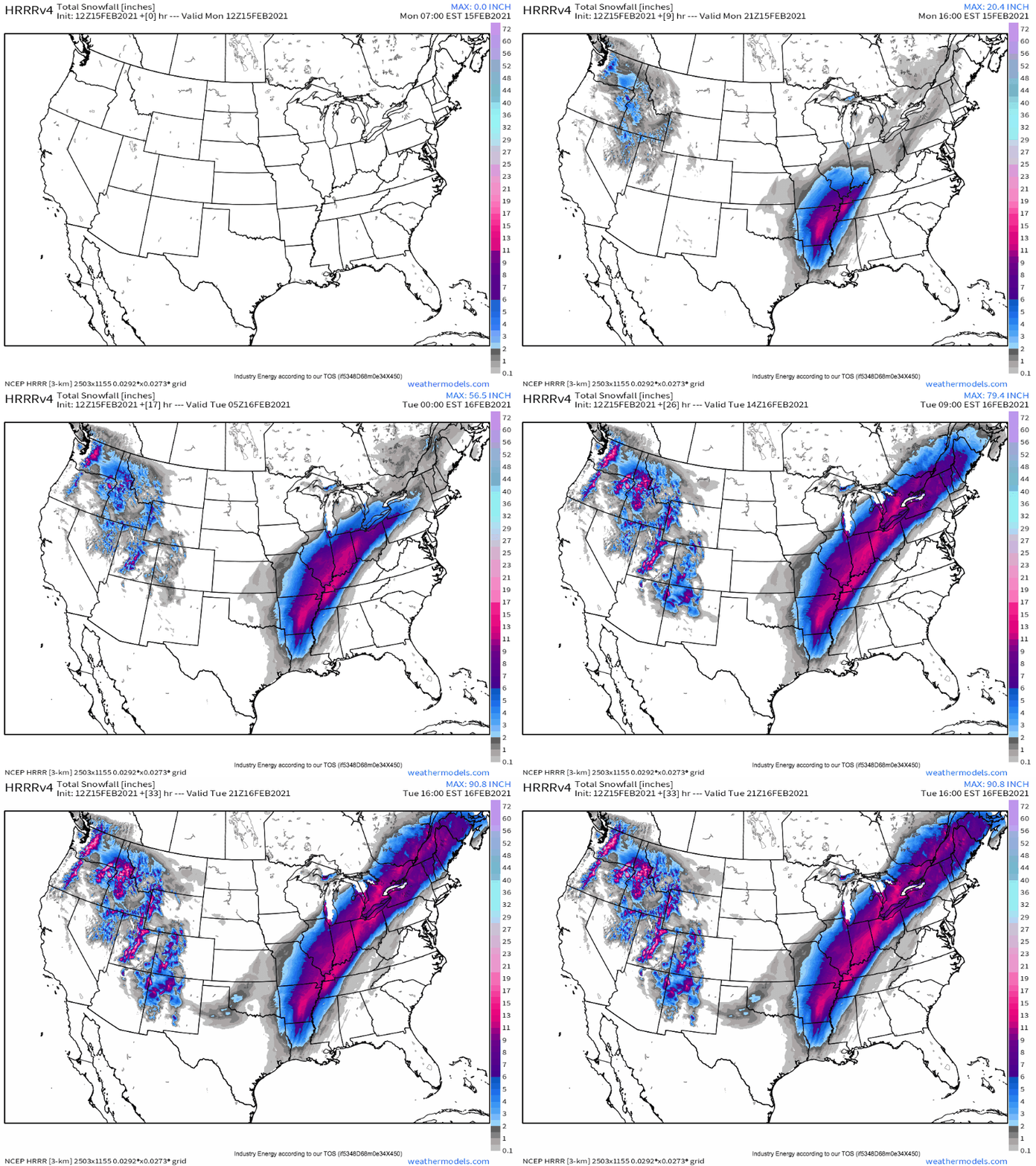
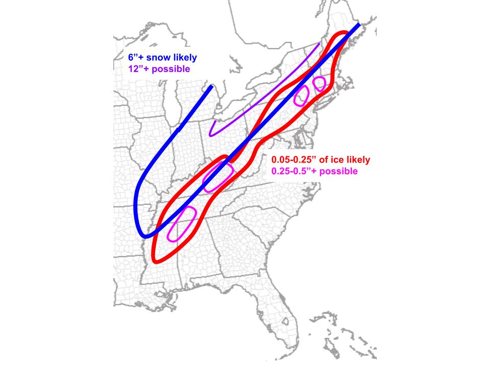
The snow forecast is relatively straight forward, as these things go. An immature, significantly vertically tilted cyclone like this will almost always have banding predominantly along and just to the north of the low to mid level warm front, which typically encompasses an area a few hundred miles across. As the cyclone moves northeast, it will move parallel to its own low to mid level warm front, meaning from the perspective of the ground, forcing for ascent will seem quite persistent even as the cyclone itself moves somewhat quickly. This will work to create a swath of 6-12″ of snow, with locally higher amounts, that is somewhat narrow. This will therefore feature pretty hefty potential for over or underachieving snow, depending on exact cyclone track, because the same areas will typically see snow.
While there is a hazard in taking these snow amounts literally due to overly simplistic ratios, it demonstrates my point well: a narrow swath of snow potentially exceeding a foot, accumulating over a relatively long time, with rapid drop-offs north.
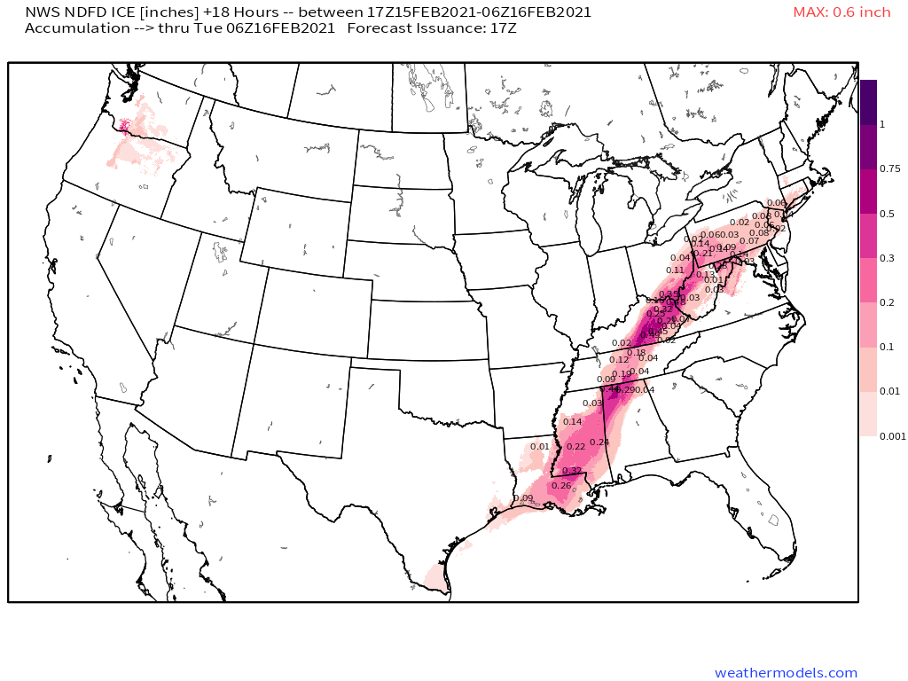
To the south of this band of snow, which remember, represents the general extent of the low to midlevel warm front, precipitation will fall through a warm layer aloft before freezing on the cold ground. Here, a significant swath of freezing rain appears likely.
This swath will be somewhat simple to nail down at first, with generally straightforward topography and cyclone evolution allowing a steady glaze of 0.25-0.5″, with local maxima potentially approaching an inch, to spread north in a narrow band. Like with the snow, the cyclone will largely parallel midlevel forcing, so light freezing rain will steadily increase in intensity over the next 24 hours for many of those impacted. This is, though late tonight, a pretty uncontroversial forecast, and so feel comfortable leaving the NDFD ice forecast graphic here:
But, as the cyclone reaches the northeast, topography will throw a wrench in the cogs of a smooth forecast.
This wrench will be the influences of cold air damming on the evolution of the surface cyclone.
Cold air damming (CAD) is the feedback process through which cold air at the surface is slow to move out in the face of at-large warm air advection, largely due to direct topography (ie, valleys refusing to let air drain) or indirect topography (ie, channeling of flow to northerly). This process in turn prevents surface wind shifts from progressing north, which maintains a degree of cold air advection at the surface, which maintains CAD, ad nauseam. The process continues until either cold air is eroded, forcing makes it close enough to incentivize the warm front to push through, or cold air advection begins again.
CAD often plays a big role in freezing rain events over the northeast, as complex topography and numerous ridgy valleys encourage it. This event will be no exception.
The midlevel warm front with this storm should end up stretched in a line from around Binghamton to near Lewiston, which will serve as the boundary separating heavy, easy snow to the north from challenging-to-forecast, messy ice to the south. It is here that cold air damming tonight will mean the difference for many between a morning with rain falling onto roads, a morning with freezing rain falling onto bridges, and a morning with ice-coated tree limbs falling onto power lines.
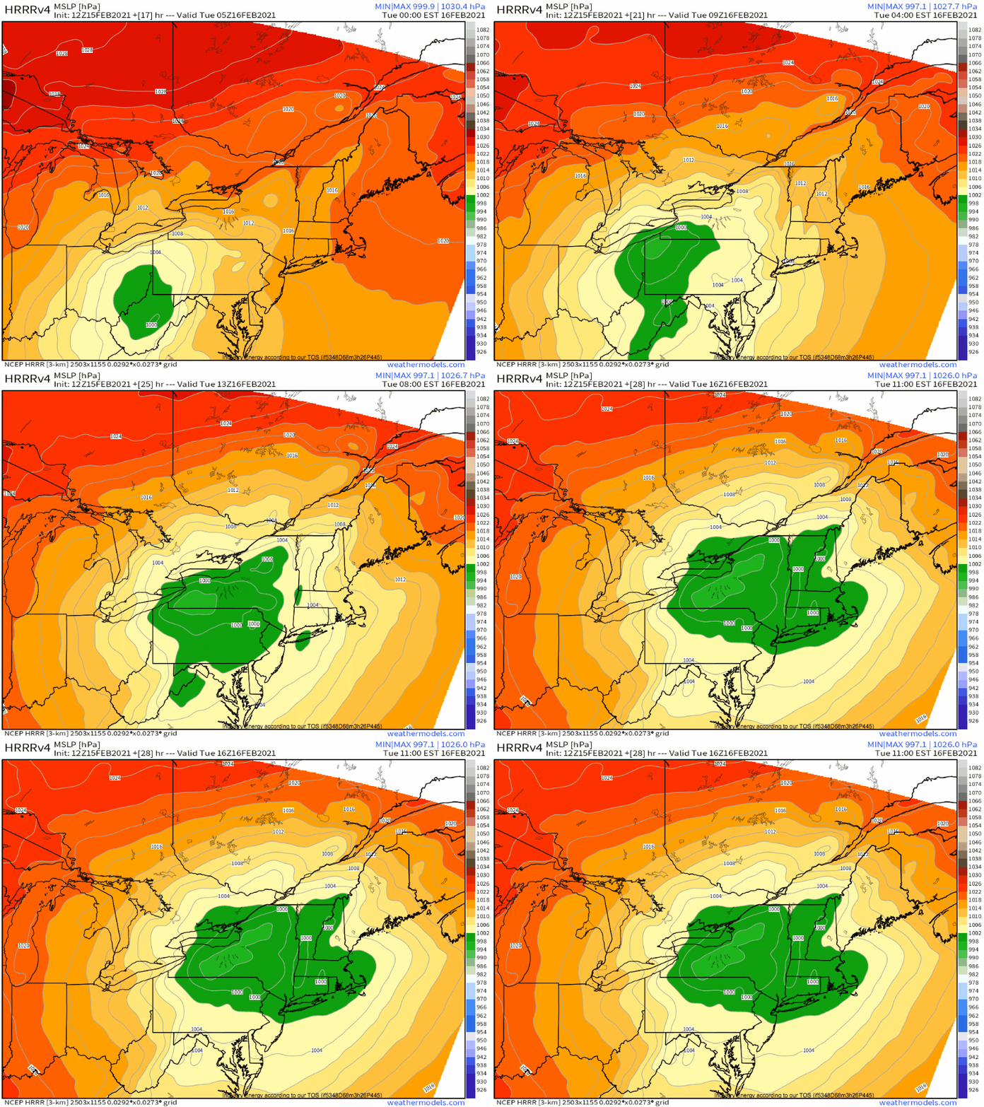
At the surface, a primary surface low moving through central NY into north-central New England will ‘split’, to an extent, along an axis of cold air damming, with a secondary surface low developing near Long Island. This is typical of southern-swinging cutter systems like this.
What’s become clear is that the primary surface low will end up stronger than initially expected, promoting southerly flow, which in turn limits broad CAD, leading to a weaker secondary development. Opposite the positive feedback of CAD discussed above, this negative feedback will prove limiting to freezing rain extent for many, with a weaker secondary low limiting northerly surface flow, keeping cold air relatively drain-able. This will help the primary surface low promote sufficient forcing to likely clear surface cold air from many of the typically edgy places- for example, the south-central CT ridges, the north-central CT valleys, and the foothills of the Catskills in SE NY. Here, a couple tenths of an inch of freezing rain will yield to plain rain by morning, in all likelihood.
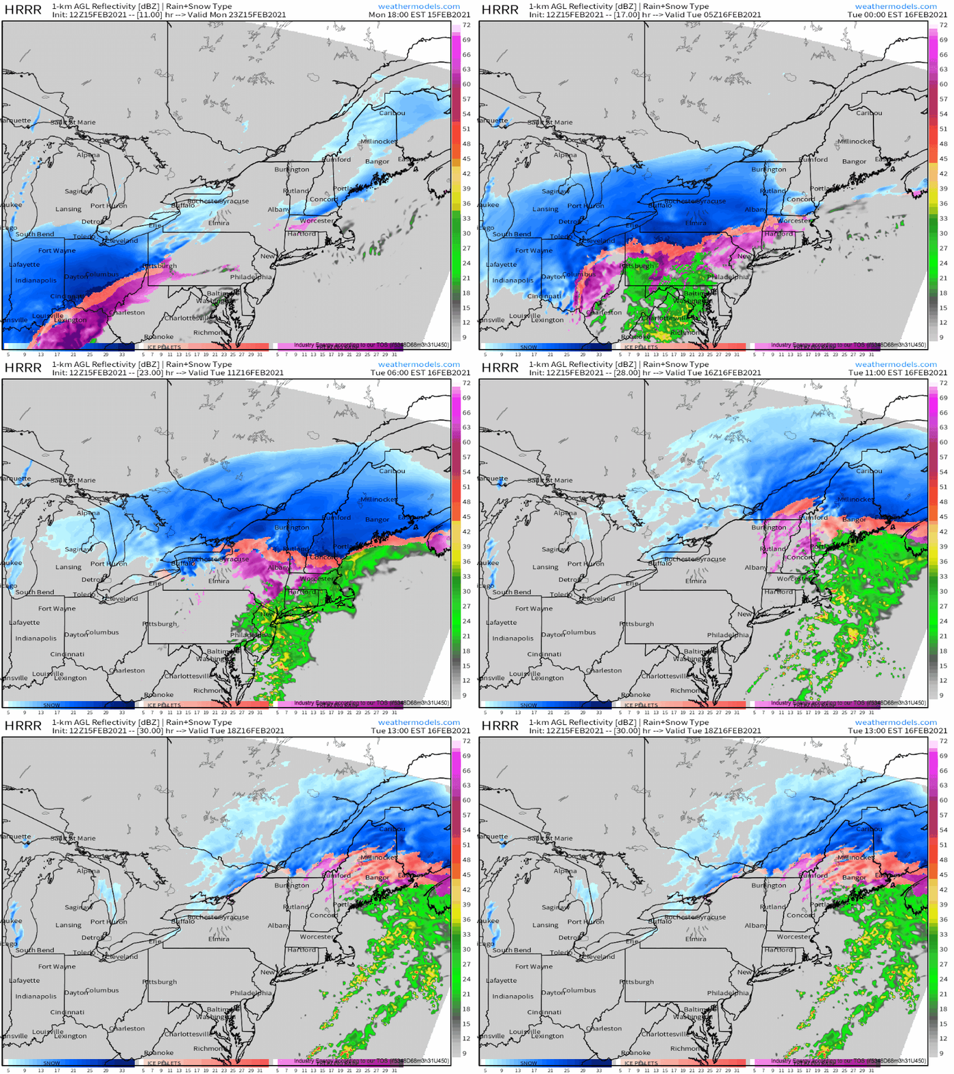
But for others, where cold air damming can hold on for longer, ice may last until precipitation ends. This is modeled by the HRRR convincingly, and should be heavily topographically dependent.
With this in mind, I would watch the ridges of western MA and far NW CT, as well as the favorably oriented Catskills and adjacent highlands of SE NY, for maximized ice potential tonight, with some power outages possible.

