Northeast Urban Corridor To See Significant Winter Storm
A well-oriented system will bring heavy snow to a very populous corridor of the US to start the work week, with 6-12″ of snow possible in Chicago, DC, NYC, Philadelphia, and Boston.
Meghan wrote a great synopsis of how the storm will come together yesterday– definitely check it out, as I’ll sort of be starting where she left off.
The storm will sort of exist in three separate snowfall regimes. They will be hard to distinguish at times, but are largely distinct temporally and process-wise, so it’s how I’ll be breaking down this blog:
- Snow with the precipitation shield to the north of the central US cyclone late tonight through late tomorrow night, with impacts in the central Great Lakes region
- Snow and mixed precipitation along the I-95 corridor in the northern mid-Atlantic, stretching to the northwest of secondary cyclogenesis from DC to Long Island from Sunday morning to Tuesday
- New England snow from early Monday to Wednesday, as tertiary cyclogenesis off Nantucket stretches the cyclone northeast.
Before we get into the blog, remember: heavy snow, like any other precipitation, is a function of lift and moisture. The situation is complicated by temperatures, which have to be below freezing in most of the atmosphere for snow, and snowfall ratios, which complicate the conversion of liquid accumulation to snowfall.
Also: as frequent readers know, the way I see a lot of significant sensible weather is as a function of persistence. Persistence turns heavy snow into high snow accumulations. When it comes to nor’easters, in which snow banding is typically driven by mid/low level convergence, “long duration” means this forcing overlapping with moisture for a long time. This can be driven by the “three P’s” of long-lasting forcing: parallels, persistence, and pivoting.
Parallels: a snow band oriented parallel to the motion of the cyclone trains forcing for ascent over one location. For a spot on the ground, this creates relative immobility of forcing, even though it is in fact moving. This process dropped 40″ of snow in southern NH and VT on December 17th 2020.
Persistence: a slow-moving cyclone means even unfavorable oriented snow bands can last a while. This is what dropped 40″ of snow in south-central CT on February 7th 2013.
Pivoting: An occluding cyclone tends to see midlevel forcing, and snowbands, that pivot around a focal point. The snowband as a whole moves over a wide area, dropping heavy snow with limited persistence, but at the pivot point, the band covers very little ground. This dropped 36″ of snow in Maryland on January 22nd 2016.
Now that that background into my thought process is out of the way, let’s dive in!
Regime 1
A surface low currently spreading moderate precipitation across the south-central US will shift north towards the Great Lakes today. As the attendant midlevel energy reaches the base of a building Canadian ridge, the system will slow this evening and begin slinking to the south tonight. A brisk southerly low level jet will intensify east of the cyclone, with typical atmospheric tilting with height putting the 850mb boundary to the north of the surface warm front. Along this boundary, which will develop over the central Great Lakes late tonight, Gulf moisture transport will overlap a significant speed slowdown, which will incentivize convergence and lift.
This will create a pretty cut and dry snow setup, with a moderately quick moving cyclone oriented nearly perpendicular to bands that slide, rather than pivot. Therefore, the storm satisfies none of the three P’s of longevity. However, the moisture field will be pretty expansive, and dynamics impressive, and so widespread moderate snow with moderate longevity is likely from northwest of Chicago through northern Indiana into central Ohio. Closer to the surface low track, rain will likely mix in, so Columbus could see a period of rain; however, most of the population centers of the area will see all snow.
This means that the heaviest snow is most likely in a simple corridor to the direct north of low track. Here, moderate temperatures and low forcing for ascent will keep the dendritic growth zone a little too elevated and narrow, suppressing snow ratios around or even below 10:1. This will mean snow will be sticky and wet for many, creating shoveling difficulties but also limiting total accumulations. And, as precipitation for some will change to rain, snow will be limited in parts of the region. Still, with a moisture-laden system, totals should be 6-12″ for many.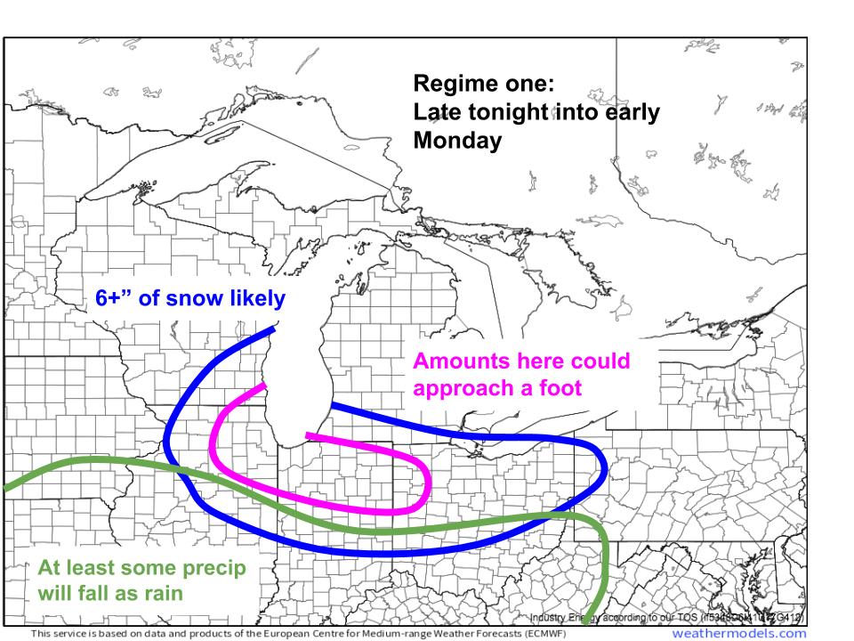
This won’t be a blockbuster by any means, but could easily cause pretty widespread travel disruptions considering the overlap with major population centers. The fact that most snow will fall on a Sunday helps.
Regime 2
As the midlevel trough approaches the mid-Atlantic coast and begins to close off, secondary cyclogenesis will begin in earnest offshore the Delmarva region. This gives the storm its Miller Type B delineation, and will also create a second precipitation regime that will include heavy snow from Virginia through the tri-state area.
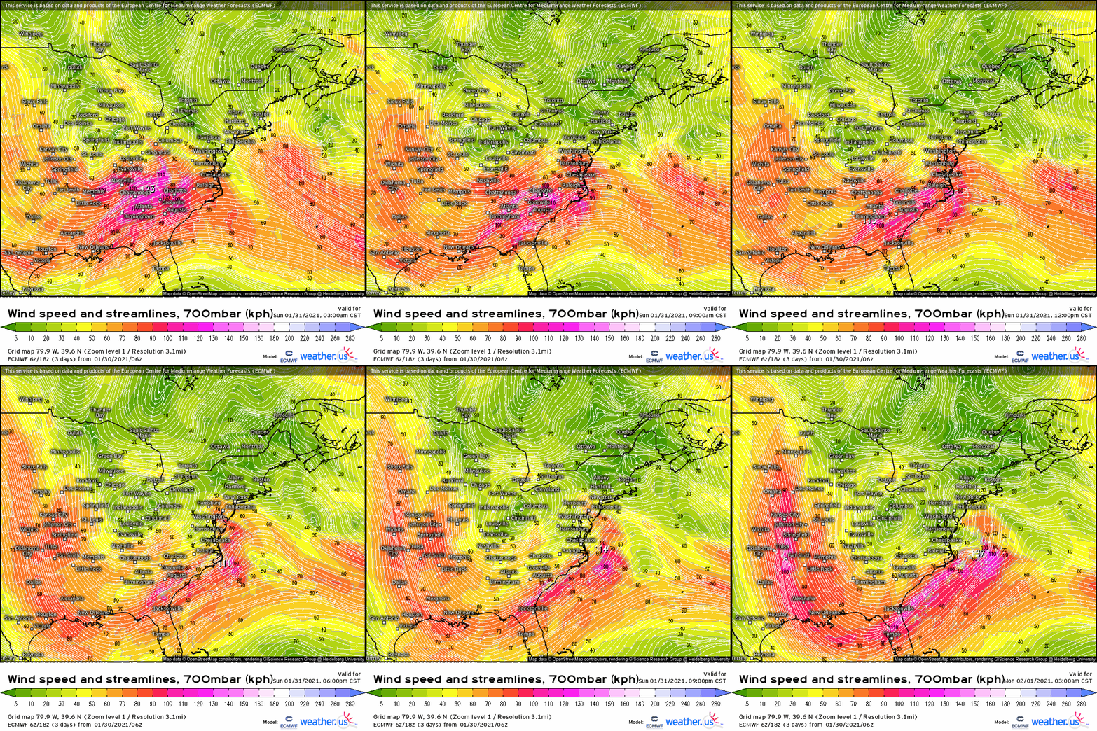
Mid-morning tomorrow will see the central US cyclone still dominant, and still producing heavy snow from the Chicago area east to Ohio. But secondary cyclone development will have already begun amidst divergence associated with the increasingly closed midlevel impulse.
A strong southerly 700mb jet will have developed south of a boundary that, due to atmospheric tilt, will be to the north of the two cyclones. This means a boundary, at which this flow slows down, will overlap an antecedent environment cold enough for precipitation to remain frozen. The result will be a shield of moderate snow spreading into the central Mid-Atlantic from the south and east. Dry air will hold its own for a few hours with limited forcing to start the show, but by noon Sunday, increasingly powerful midlevel flow convergence means snow should begin in earnest from Virginia through Pennsylvania and Maryland, into Delaware.
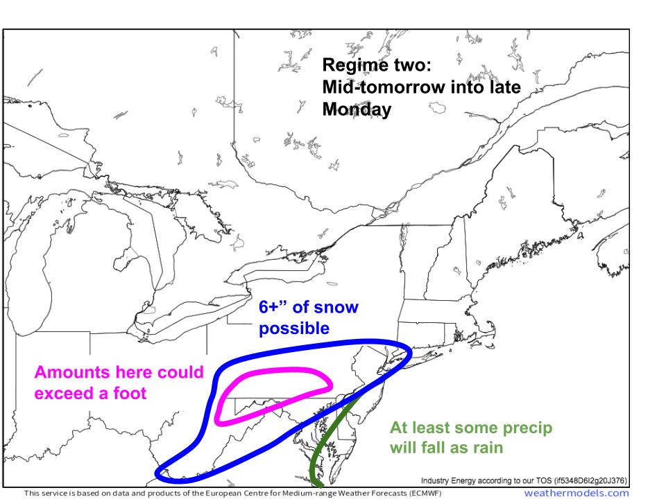
The stretching 700mb boundary will slow significantly over parts of Pennsylvania, Maryland, and New Jersey tomorrow. In this area, a mixture of persistence (cyclone as a whole won’t be moving all that fast as energy transfer commences) and parallel (the 700mb convergent boundary is located parallel to the line along which the energy transfer will occur) could create longevity of moderate snow. This zone will likely see a local maxima as convergence and moisture stick around for the longest and dump accumulations potentially exceeding a foot.
As the primary cyclone begins to dissipate east of the Appalachians Sunday evening, signaling a largely complete transfer of energy to secondary cyclone, 700mb flow will strengthen, strengthening the boundary and associated ascent in turn, while also pumping in moisture. As a result, snow banding will likely intensify. The orientation of the 700mb speed convergence along a now stretching secondary cyclone suggests a band of heavy snow Sunday night will progress north, dosing much of the northern mid-Atlantic with a “thump” of heavy snow. In the wake of this band, snow rates will decrease, with some places turning to rain. Right now, it looks like parts of the Delmarva and southern Jersey, poisoned by proximity to the surface low, will transition to rain by Monday. This will set the scene for regime 3.
Monday could see some pretty widespread travel difficulties in the DC and Philadelphia metro areas. This will be the heaviest snow in years for both cities, and motorists should travel with caution.
Regime 3
This regime is the most complicated, will feature the potential for significant snow from NYC through Hartford and into Boston, and has a great deal of uncertainty still attached.
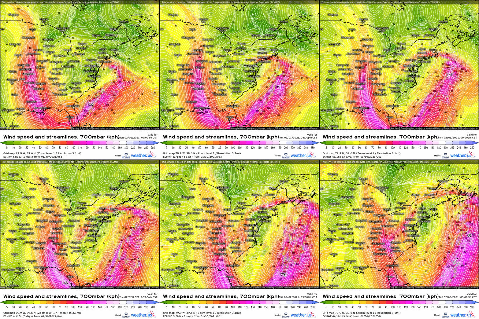
It will start with the intense band of 700mb speed convergence sliding north through the mid-Atlantic Monday. As the mid to upper level low deepens and consolidates, the low to mid level cyclone will stretch towards Nantucket, with one lobe remaining anchored beneath support aloft near Delmarva. This stretching along a focal point will create a setup in which the 700mb gradient could pivot near the secondary low, while the band swings around to the north with tertiary development. In this GIF, that becomes clear around 6pm Monday from Harrisburg northeast towards NYC.
So, there will be a pivot of forcing. This could end up the jackpot for snowfall, as a booming band of ascent stays largely stationary. But, of course, there’s another element: moisture.
As the secondary cyclone intensifies Monday, a roaring low level easterly jet will pull a great deal of Atlantic moisture inland, where it will smack into the 700mb speed convergence amidst sub-freezing temperatures. However, the orientation of 700mb convergence largely parallel to the lower level jet may actually limit moisture near the pivot point. This is an important conditional; if the pivot point can tap sufficient moisture, 20+” of snow could well fall. If not, snowfall rates will stay muted. It’ll depend on mesoscale organization of jets at both ~700mb and ~850mb, and so it’s a little too early to say. But the potential is there for a blockbuster storm for parts of NE PA and NJ.
So, there will be a pivot of ascent, probably. But there’s also a whole band that will be swinging across southern New England to worry about.
The stretching of the cyclone northeast could also allow the motion of the 700mb forcing to, at least for some time, get stuck parallel to its orientation. I’m watching two zones for this potential: one in the tri-state area, from the vicinity of NYC to parts of SW CT and Long Island; and another in NE CT into NE MA, including Boston, as the tertiary cyclone begins to deepen early Tuesday.
This all means that, while much of south central New England and perhaps parts of central New York will see heavy snow as the band of ascent moves around amidst shifting 700mb convergence, three areas could see local maxima: a pivot from Harrisburg to parts of NJ, a parallel in parts of SE NY into SW CT, and a second parallel from NE CT towards Boston. The longest lasting should be the pivot, and that’s where I’m pinpointing as the most likely area for maximum totals.
As the tertiary low becomes dominant late Tuesday, heavy snow will shift inland into interior New England and Maine, possible as far NW as central NY state. This is when the second parallel will be most probable in the location I’ve described, but this could still change- it’s quite far out and the set up is very complex.
Now, there is a catch with this beautiful map.
Models have been trending steadily NW lately, and so there’s totally a chance all of this could end up further NW than shown here. It’s still several days out.
Well, that was a lot. Here’s a summery graphic: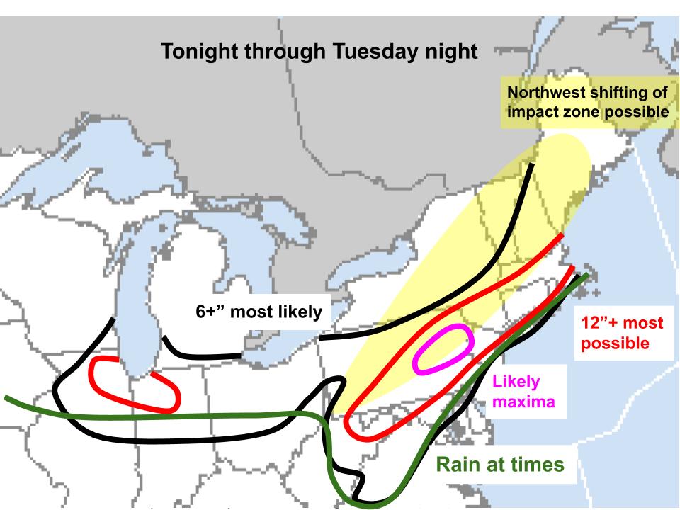
Enjoy!


Hey jacob-
Stumbled onto your blog by accident yesterday looking for “non media” (ie: academic) analysis of the impending nor’easter. Your blog is now bookmarked for me. For a novice weather enthusiast like me, I prefer the detailed technical analysis like you offer than 95% of whats out there.
Without having looked too deeply into your blog (perhaps I may have missed it), you may want to consider making videos describing your analysis – a la what Levi Cohen does over at tropical tidbits for tropical storms.
Either way – keep up the good work! I look forward to your future posts.