Significant Impacts Expected As Atmospheric River Hits California
An atmospheric river event of somewhat uncommon intensity and duration will landfall in California today, with copious precipitation and significant wind impacting much of the state. Extreme snowfall will make for impassable roads down to the foothills, and where heavy rainfall overlaps burn scars, local devastation is possible amidst mudslides.
First, a review on atmospheric rivers.
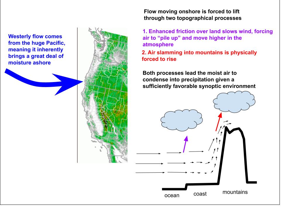
As regular readers of this blog are by now well aware, topography can often act as something of a weather machine, crafting significant sensible weather with limited atmospheric input.
An example of this is on the west coast, where proximity to ocean promotes significant moisture advection given westerly flow, and the landscape promotes lift through frictional and orographical convergence.
This means that, given sufficient synoptic-scale lift and westerly flow, heavy precipitation can occur in an event called an atmospheric river, named from the ‘rivers’ of atmospheric moisture that advect onshore. Simple as that, really.
Because topography doesn’t tend to get up and walk away, it’s pretty easy to get very significant sensible weather impacts with these landscape machines at the hands of persistence. The fewer moving (or, atmospheric) pieces involved in a weather event, the more likely it is to persist for a long duration. And, as a general rule, long durations dramatically increase impact.
This all means that, if the atmosphere can contort itself into a pattern that allows persistent onshore flow and synoptic-scale support for lift, significant sensible weather can occur on the West Coast. That looks to happen this week.
As is typical for significant California atmospheric river events, the issues begin as anomalous ridging into Alaska and blocking downstream allow a significant trough to develop off the west coast. 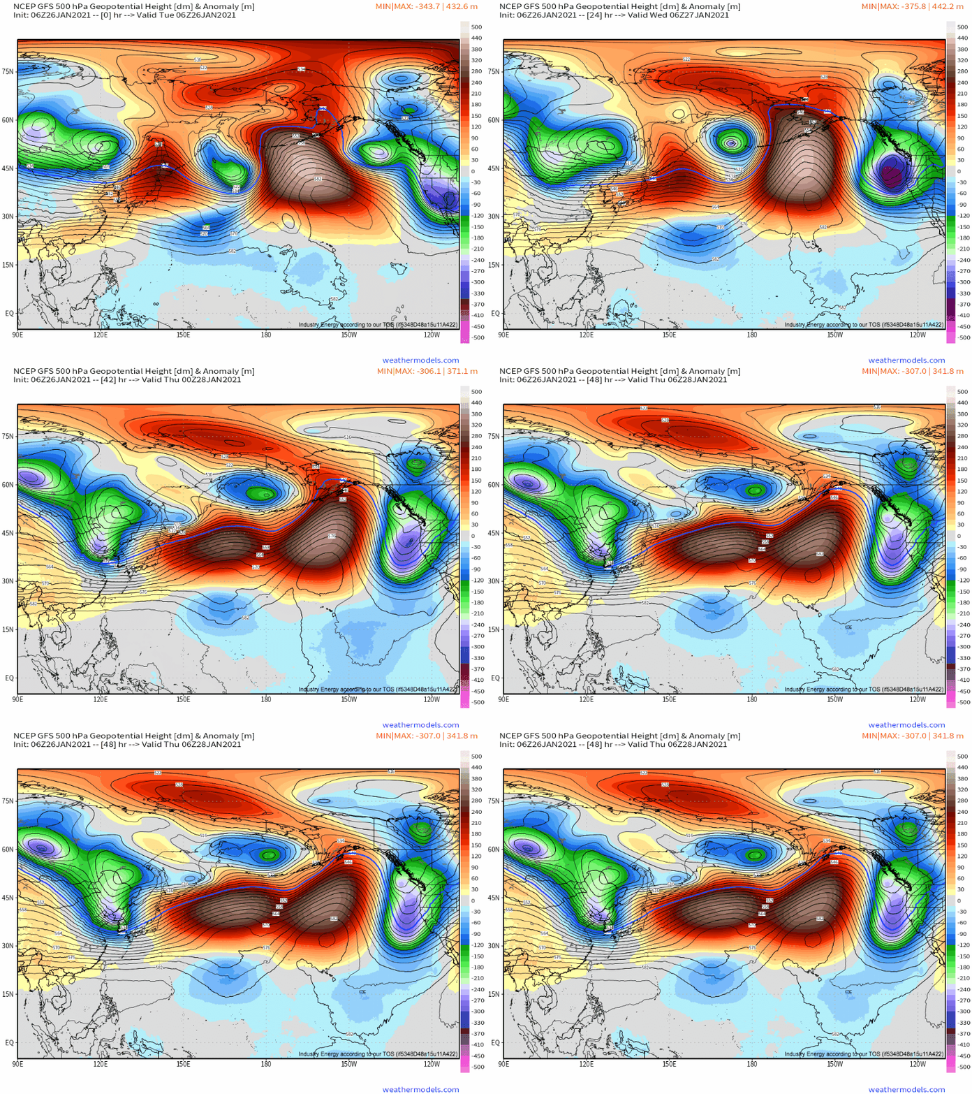
This will force the height field aloft to stretch between this anomalous west coast troughing and the more typical midlevel low over NW Canada.
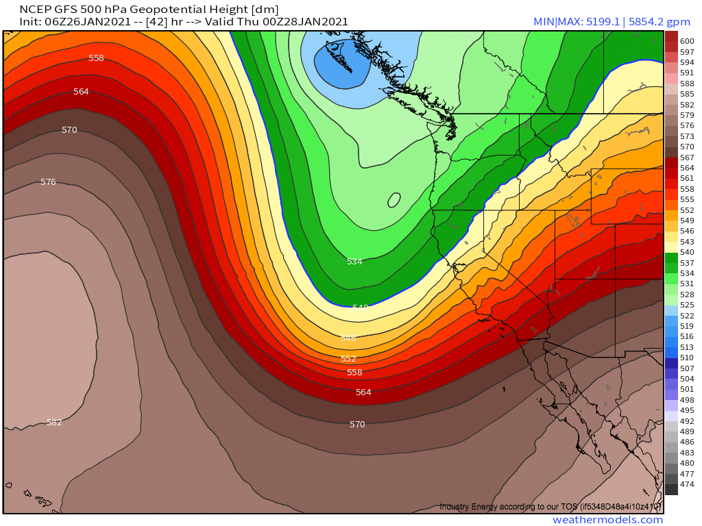 The result will be a flow regime with a few important characteristics:
- A strong, ‘taught’ gradient that won’t really waver. The result will be a persistence that encourages other persistences. Bear with me.
- Enhanced divergence along this gradient, as heights spread horizontally with distance from the base of the trough. Synoptic scale lift results, which will encourage the ascent required for precipitation while also evacuating mass over the western CONUS. Because the gradient won’t waver, this will persist.
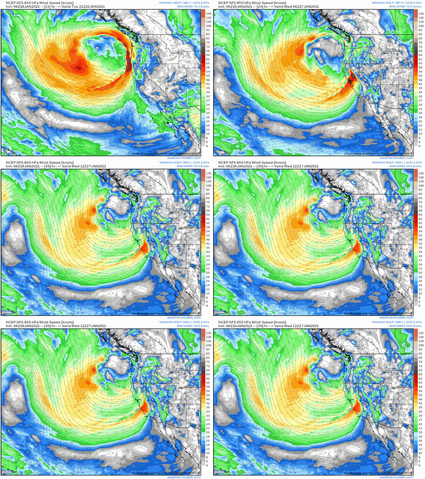
- The evacuation of mass over the western CONUS will promote a powerful low level jet, as air races to fill the void. This onshore jet will pull deep moisture with it. Because the enhanced divergence won’t really move, the jet won’t shift side to side much relative to the attendant low level cyclones.
- Finally, shortwaves moving along this gradient will move parallel to the gradient itself. This may seem obvious, but is actually not typically the case for more progressive systems. This means, in turn, that low level cyclones will persistently move largely parallel to their low level jets, which increases the potential for longevity of LLJ impacts at one location. This translates to extreme precipitation and high wind impacts.
That may have been a little confusing to grasp, but the point should be taken that parallels are a poor man’s persistence: the atmosphere never actually sits still, but it can feel like it is from the perspective of the ground if enough things are moving in the same direction. 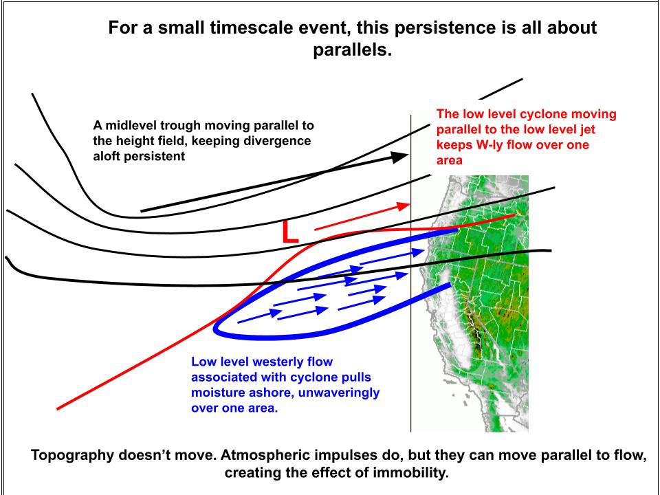
Ok, wow, that was dense. Back to the actual atmosphere.
As the jet re-orientation begins later today, a round of moderate precipitation will overspread much of the West Coast, associated with an initially N-S oriented LLJ. The lack of atmospheric parallels means it’ll be something of a quick-hitting regime, and precipitation intensity will quickly wane in much of Oregon and Washington.
But the southern flank of the jet is oriented significantly more W-E, increasingly parallel to the much-discussed broader pattern. And as this portion of the jet landfalls in NorCal tonight, it will bring significant precipitation that won’t really go anywhere quick.
The low level jet will shift slowly south through California tomorrow as the trough that makes up one pivot of the height gradients shifts south.
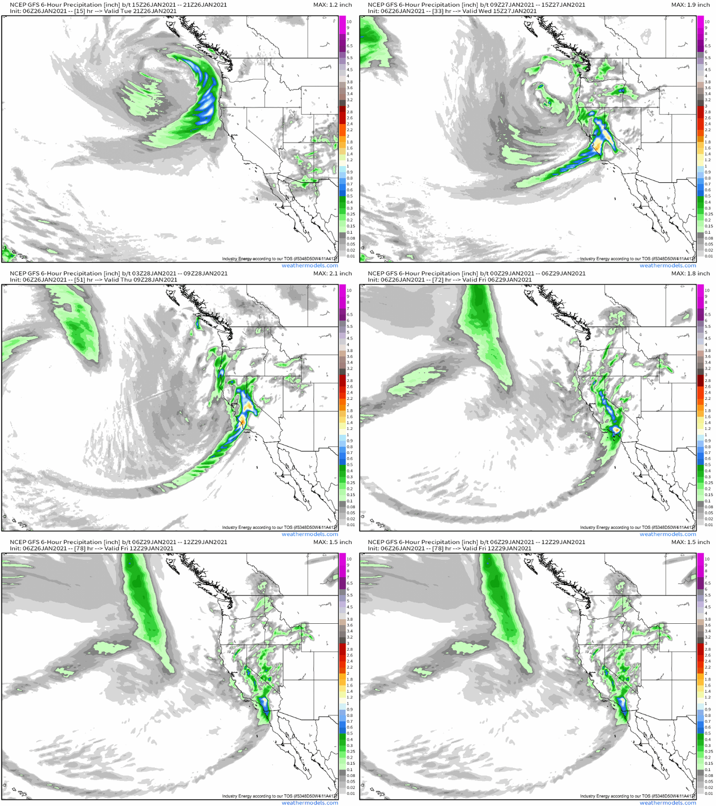
Just because lift can occur spontaneously based on topography doesn’t preclude an additional atmospheric boost. That’s exactly what will happen tomorrow, as convergence zone in low level flow steers down the coast. It’ll spread a band of very heavy precipitation south tonight into the mid-morning tomorrow. Impressive dynamics will encourage scattered lightning with this band, and powerful flow not far above the surface will bring damaging wind gusts to the surface.
1-3″/6hr of rain will be common as the band shifts south, which could well cause significant mudslides along burn scars very early tomorrow morning. This will be the biggest threat from the storm, and those in the shadows of burn scars should absolutely have multiple ways to receive weather alerts.
This will be a cold storm. Impressive negative temperature anomalies that brought a hard freeze to much of the central valley mean snow elevations will be quite low, and much of the valley north of Sacramento will see an impressive sock of dense, heavy snow in an unusual winter storm.
Extreme snow will be falling at higher elevations, meanwhile, and travel will quickly become impossible in the Sierras, coastal ranges, and many foothills.
As the convergence zone shifts south of NorCal, moderate precipitation will continue, especially where topography favors orographic lift of onshore flow. In the mountains, extremely heavy snow will continue to fall. Snow heights will rise, though, transitioning areas such as the northern valley to on and off steady rain. The coast will continue to see rain at the hands of frictional convergence.
Around noon tomorrow, the convergence zone will stall near the Big Sur region of central California as the midlevel system achieves maximum ‘parallel-ing’. The result will be persistent heavy rain and damaging winds, and 10-15″ of rain could easily fall near the coast, where frictional convergence will be maximized. Flash flooding and mudslides, even away from burn scars, will be quite possible here. Further inland, orographic lift in the Sierras will create truly absurd snowfall, likely exceeding 7 feet in places. Both heavy wind and snow will be accompanied here by long-duration damaging wind gusts, likely compounding any issues.
Thursday, the convergent zone will continue to shift south, leaving most of the state in a more showery, topographically forced precipitation regime. Very heavy snow will continue in the mountains, with showery rain persisting along the coast and in the hills. But along the convergence zone itself, significant precipitation rates will continue to spread slowly south along the southern coast of California. While still packing a punch of strong wind and heavy rain, intensity will have waned somewhat, and lesser rates and accumulations are expected this far south.
By Friday morning, most of the state will be seeing lighter, more showery precipitation, with weaker onshore flow limiting any durable rain and snow to topography. What does fall won’t be nearly as intense as the earlier precipitation. By Saturday, the state should be effectively clear.
Another, potentially robust atmospheric river event will occur early next week. Hydrological impacts could end up reasonably significant due to the priming provided by this event, but that discussion will have to hold off until predictability increases somewhat regarding the second storm event.
…
To restate: An unusual band of very heavy rain will slink down the California coast tonight and tomorrow significant. In burn scars, significant debris flow could occur. Those potentially impacted should have multiple ways to receive weather alerts.
Flash flooding and an isolated debris flow could also occur near the Big Sur region Wednesday into Thursday. For those in this region, it is also important to have multiple ways to receive weather alerts.
