Winter Returns to the Northeast Saturday
At long last, after languishing in a quiet period of above-average temperatures, the Northeast will see the return of winter weather once again tomorrow.
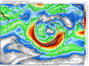
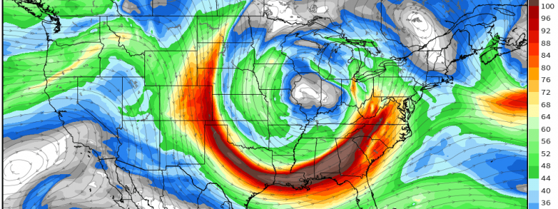
A strong, cut off, bowling ball of cold air (upper level low) will perpetuate eastward during the day today and brings with it wind, rain, cold air, and, of course, snow. Before y’all get too excited though, understand that for the I-95 corridor, this will be a rain event. The snow will be found far inland and in the mountains for a few reasons.
These being:
- Temperature
- Lack of moisture
Above average antecedent temperatures, lack of any true incoming arctic air, and warm air advection from the southeast due to the position of the low will work together to keep the coastal areas just warm enough to receive nothing more than a cold rain with maybe a few pellets of sleet mixed in.
As for the moisture…
This is a fairly moisture-starved system. Any significant precipitation relies on what mositure the storm can “create.” This will happen in a few ways.
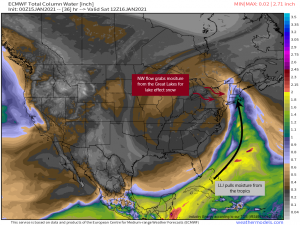
First: Advection via the strong low level jet. The counter-clockwise flow around the low will pull moisture from the tropics as it moves eastward. Unfortunately, this moisture also comes with warmer temperatures which are also advected north. Since the center of the low will remain inland, the air won’t have time to sufficiently cool before reaching the coast. Therefore, any precip that falls here will be rain.
**It’s also important to mention that the LLJ bringing the moisture will also be bringing the winds. Gusty winds will be likely at the coast and in the elevations through Saturday. Though not on the scale we have been seeing in the central US, gusts in the 60 mph range are on the table and could cause the odd power outage.
Second: Orographic lifting. The topographical forcing of the moisture higher into the atmosphere allows the system to basically wring out every last drop over the elevations. This, combined with the naturally cooler environment of the elevations means the snow will fall in the greatest quantities here.
Third: “Stealing” moisture from the Great Lakes. Behind the center of the low, the flow changes and comes from the northwest. It then blows across the lakes, picking up moisture as it goes and depositing it, in the form of lake effect snow, on the opposite shores. We will also see enhanced snowfall totals in these areas.
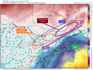
So the precipitation map will look a little something like this:
Keep in mind, should temperatures in the border regions nudge one way or the other, those locations could switch from rain to snow or snow to rain. The boundary lines aren’t set in stone, as we always see with every winter system that has no true arctic air in place. Also, any elevated topography in the “rain” circles has a higher chance of seeing snow vs rain due to cooler temperatures further up. I’m mainly talking about parts of the Appalachians through New York and even NE Pennsylvania.
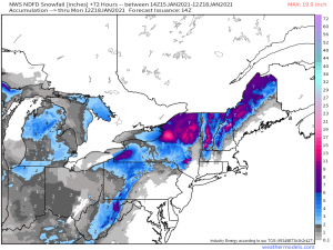
The highest snow totals will be found in the elevated topography of ski country (skiers, rejoice!). The enhanced totals from lake effect snow on the back side of the system won’t be anything to sneeze at either.
Areas east-southeast of the lakes could easily pick up totals approaching a foot.
The northeast has been deprived of a snow/cold-lover’s winter for most of the season so far. Perhaps this will be a turning point in the pattern and the latter half of the season will be more seasonable.
Have a wonderful weekend!
