Damaging Wind and Flooding Possible With Significant East Coast Storm Thursday
A significant ‘warm’ storm will bring potentially significant sensible weather threats to many on the East Coast Thursday evening into Friday morning, with damaging winds and flooding both possible, especially in parts of the mid-Atlantic and Northeast. This blog will be split into three sections: a synoptic overview, a look into the damaging wind threat, and a look into the heavy rain and flooding risk.
Part 1: The Synoptics
The split CONUS flow days of mid-December are over. Our story starts with a somewhat compact but intense trough over the Pacific northwest, which already brought significant wind, rain, and even snow to much of coastal Washington and Oregon. The trough will dive southeast tomorrow, as a ridge building into the west coast and a secondary midlevel impulse collaborate to pull the height field into a full-CONUS longwave. On Wednesday, as the secondary impulse rides the northern extent of the trough axis, closing off into a midlevel low over the Michigan UP, a powerful low level cyclone will develop over the Dakotas. The result will be a powerful low level jet, as powerful southerly flow begins marching towards the intensifying cyclone. Meanwhile, a third shortwave will begin sliding south over the western edge of the trough. By Thursday afternoon, as the primary low level cyclone begins winding down over central Canada, this third shortwave will close off into a powerful closed low over the middle of America. As divergence overspreads the east coast ahead of the midlevel feature, a second low level cyclone will develop along the cold front draped beneath the first. Thursday evening and night will see the closed low intensify and slide northeast as the secondary low level cyclone intensifies quickly, moving from the Carolinas to the Great Lakes, and allowing the low level jet that developed over the western US Wednesday to rapidly strengthen. Because the closed low will stretch out the midlevel trough, flow will end up largely parallel to these two cyclones. So, although the cyclones themselves move fast, the low level jet won’t, and will instead remain largely in one place as it intensifies.
That was a lot to take in. Here’s a loop from the Euro model of what looks likely to go down this week in the midlevels: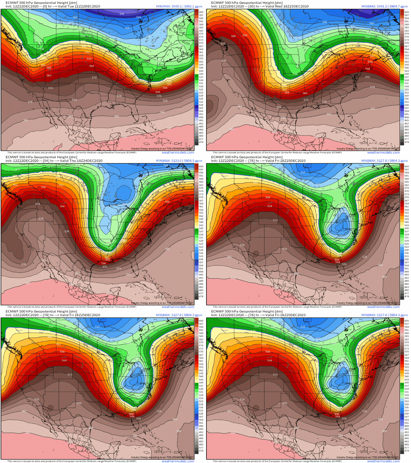
Weathermodels link, Weather.us Link
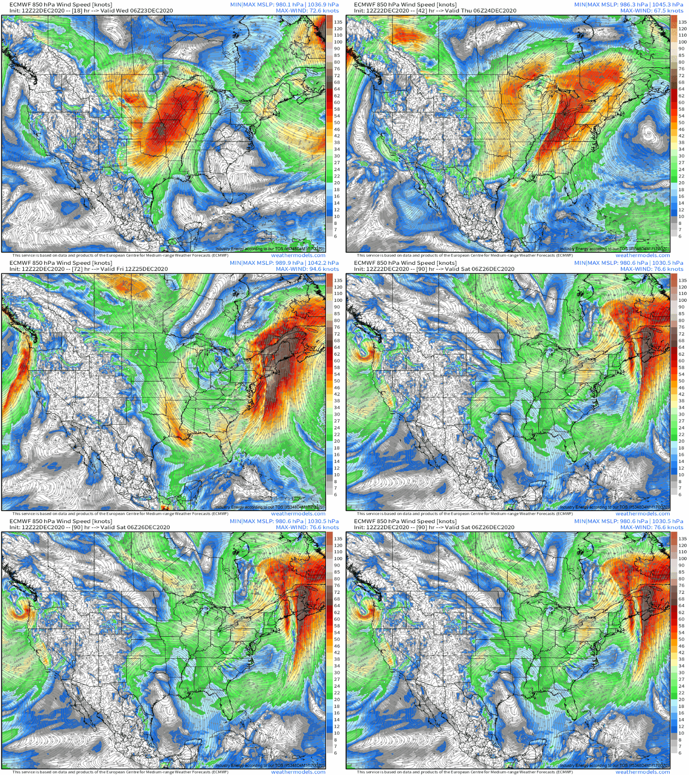
At the 850mb level, meanwhile, you can watch the jet that I’ve described evolve:
Ok, so we’ve gotten the set up out of the way. Now, on to impacts. Let’s start with the damaging wind threat.
Part 2: The Wind
As the low level jet intensifies and slides across the Northeast and mid-Atlantic Thursday night and Friday, it will likely roar in excess of 90 knots. This immediately catches a forecaster’s eye: it’s quite a bit more intense than the usual December southerly LLJ, and could spell significant gusts at the surface. Naturally, though, there’s more to the equation of sensible wind than a simply conversion ratio of LLJ->gusts, regardless of what your favorite weather model site may tell you. In fact, damaging wind is typically a two part equation: the pressure gradient that actually gets the air moving, and the processes that allow that moving air to translate to the surface, where friction generally prevents significant surface wind from developing out of pressure gradient forces alone.
As discussed above, the PG flow above the surface is not going to be a problem here. The strengthening secondary cyclone will significantly tighten the pressure gradient around a thousand feet above the heads of those on the east coast, and winds up there will be ROARING. The strongest winds look to pass over southeast New England. So, let’s see if that wind can reach the surface!
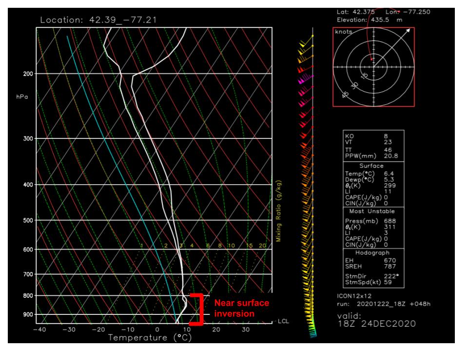
There are two main mechanisms of surface wind transfer to look out for, at least with southerly LLJs like this. The first is ‘typical’ mixing, which occurs absent of convective processes. It’s helpful to look at the atmosphere’s vertical profile with events like this, and see what it can tell us. Enter: the modeled skew T!
At first glance, I can already tell that modeled wind gusts won’t be much use. This is because we have a low-level inversion on our hands, which often prevents the type of simple mixing ratio built into model sites.
So, mixing will be nonzero but poor with the inversion in play. However, this sounding, which does already display significant low level winds, was taken for near Albany on Thursday evening, a couple hundred miles and ~12 hours from the LLJ’s core passage over southern New England! With this in mind, it seems pretty probable that, despite lackluster conditions for mixing, flow aloft will be so dang rapid that strong gusts will be possible.
The second way strong winds can often end up at the surface in southerly flow events is via convection. In this process, the ups and downs of convective motion can transfer some of the LLJ’s momentum to the surface, allowing significant wind gusts in storms that go beyond what either the convective environment or the mixing environment support. It is this process through which I fear wind damage will be possible in the northeast and mid-Atlantic Thursday night.
Now, near surface inversions don’t usually suggest a convective event, as they tend to mean an environment with very poor instability, and Thursday night will be no exception. But turbo-charged cold frontal lift, ample moisture advection, and extreme wind shear can end up plenty supportive of squall line continuation with even very marginal non-surface instability. This means that we shouldn’t expect a squall line to develop over the northeast Thursday, but if one does develop upstream, it totally could maintain its intensity while it moves through the region, potentially causing widespread damaging wind gusts via convective momentum transfer.
This is where an additional layer of complexity is added. Suddenly, we have to forecast a potentially extremely finicky mid-Atlantic HSLC severe event in order to figure out how much damaging wind potential will exist over NY, CT, and MA?
This injects a lot of uncertainty into our forecast, a discussion of which would double the length of this blog. But take my word for it: an environment somewhat favorable for convection will probably exist over the Carolinas, and strong to severe thunderstorms will probably develop along the cold front. Considering the roaring shear and intense linear forcing, these storms will probably coalesce into a squall line. If this does happen, which seems more possible than not but far from assured, incredible forcing and extreme wind shear will probably ensure that the squall line is able to wreck havoc under the core of the LLJ.
Wow, that was a lot. Hopefully you have a better understanding of the damaging wind potential with this storm. To summarize: all areas will see strong gusts, but mercifully marginal mixing will prevent the most extreme winds from reaching the ground. However, a strongly forced squall line from upstream could bring down swaths of very gusty winds, anyway. Whew. Now onto flooding concerns.
Part 3: The Rain
Based on what I’ve seen so far, I think rain will be the biggest issue with this system. Remember: rain needs lift and moisture. Everything else is secondary. The longer these parameters stick around, the more rain will fall, and the more we have to worry about flooding.
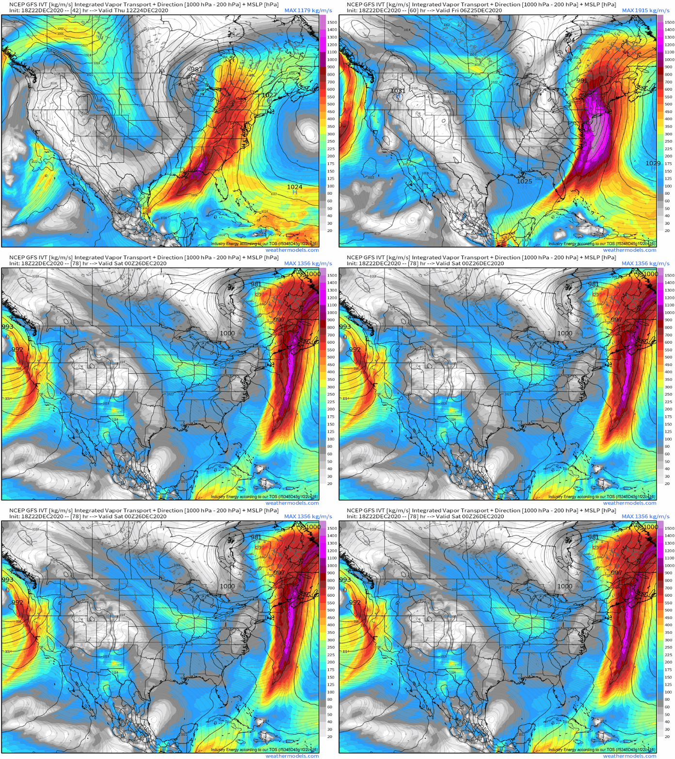
Roaring flow often means significant advection, and Thursday will be no exception. In this case, the 95 knot airmass conveyer belt set to unload over the northeast will be fed by plentiful moisture from the Gulf and east-central Atlantic. The result will be moisture advection that’s nothing short of extreme, as shown by massive integrated vapor transport hosing down the region:
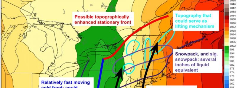
This moisture advection is only half of the equation, of course. Lift is also required; it should be as persistent as the moisture to truly maximize flooding potential. There will be a few sources: of course, the cold front, but this should be moving too fast to be the focus of any significant rainfall. Broad synoptic scale lifting will also allow numerous showers ahead of the cold front, but this shouldn’t be enough for significant accumulations in any one spot. While the atmosphere moves a lot, though, landscapes don’t. This means topographically enhanced lift could allow significant local rainfall- the moisture is there. This is either directly, through orographic lifting in the New England terrain, or indirectly, as topographically enhanced thermal gradients allow fronts to set up and stall, focusing persistent convergence.
Two other complication factors: a potential squall line, which could efficiently wring the atmosphere’s precipitable water into significant, short duration precipitation; and the snow pack, which will likely melt with the day’s warmth and heavy rain and add a few inches of water to the mix.
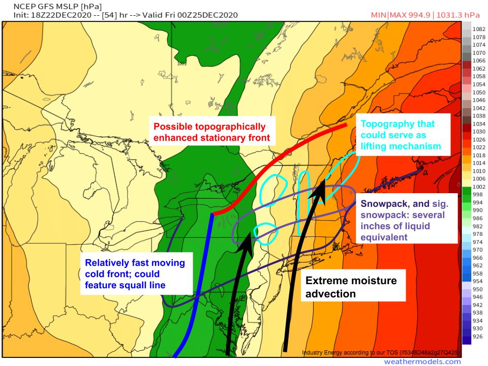
I’ve diagrammed how I see this all working out on Thursday night here, showing the overlap of extreme moisture advection, lifting mechanisms, and snowpack.
With this in mind, it looks like flooding could be a big issue where topographical lifting, or coincidentally persistent atmospheric lifting, overlap with the snow pack, given the strength of the moisture infusion. This looks most likely over parts of central interior New England and over western New York, as the former features direct topographical lift and the latter features indirect topographically enhanced frontal lift. Because both are land mass enforced, they prove more predictably persistent than atmospheric lift.
That was a lot! To summarize, expect scattered power outages and flooding in the Northeast. Have a nice evening!
