91L Threatens Texas and Louisiana With More Unwelcome Rainfall
While all eyes were on the stretch of the Atlantic northeast of Bermuda where invest 90L was attempting to get it’s act together, invest 91L snuck in under the radar.
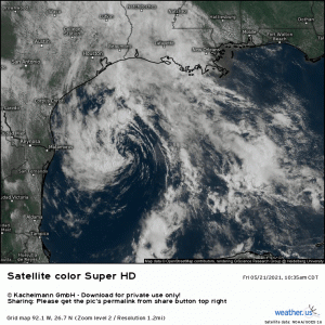
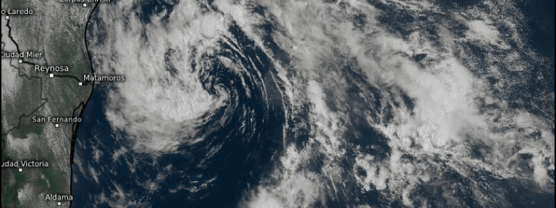
Despite it’s picturesque swirl, it is currently a relatively disorganized area of low pressure left over from a stalled frontal boundary with a few roadblocks to it’s development. These are time, SSTs, lack of convection, and dry air.
- Time
91L is forecast to come ashore sometime late tonight or early tomorrow. Though it’s low level circulation is improving and beginning to stack up vertically with the mid/upper circulation, it hasn’t attained tropical depression status yet. It would likely need a quick burst of activity and a friendly environment to push it into depression status. There is a chance that the friction encountered while coming ashore could provide enough convergence for a brief burst of intensification. This happened with Tropical Storm Imelda in 2019. The difference, however, is that Imelda, which impacted Texas in September 2019, was able to take advantage of warm waters near the coast to fuel its quick intensification.
- SSTs
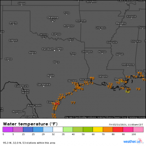
Which brings us to another roadblock. The sea surface temperatures are rather sub-par at the moment.
Water temperatures along the coast are in the low to mid 70s at best. Generally speaking, tropical systems require a water temp of 80 degrees or higher to really fuel them and intensify. While the southern Gulf/Caribbean is already seeing SSTs of 80 and over, the northern Gulf, where 91L sits, just isn’t there yet. To overcome the lack of heat from the ocean, a storm would likely have to be already producing it’s own fuel via latent heat release.
- Lack of Convection
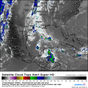
We all know from past hurricane seasons that when we see those cold cloud tops bubbling up around the center of a storm, it’s on. Well, 91L just doesn’t have it.
There is very little convection to begin with, and to make matters worse (or better, if you’re not wanting to see development), any convection that does exist is displaced well south-southeast of the center. So far, it’s been unable to wrap around the forming core and really strengthen the storm. As mentioned above, friction introduced as it approaches shore later may provide enough convergence for a brief burst of activity, but it will likely be too late at that point for anything much to come of this mess.
- Dry Air
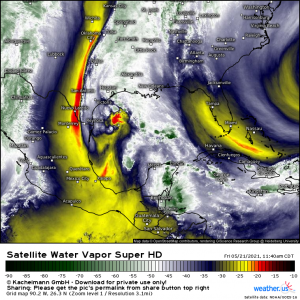
Dry air is a tropical cyclone killer. When dry air entrains into the circulation of a storm, it forces evaporation which is a cooling process. With the storm cooling down via evaporation instead of releasing heat to fuel itself with via condensation, it weakens.
And that’s what is going on with 91L. With a lot of dry air being pulled into the circulation from the southwest, it’s effectively choking off any convection 91L may be trying to fire.
So, with 91L short on time, ocean heat, meaningful convection, and suffering from dry air entrainment, any significant intensification is unlikely. At best, it could briefly attain depression or MAYBE tropical storm status, though the latter is somewhat unlikely at the moment considering all it has going against it. Never say never, though. If the 2020 season taught us anything, it would be that.
All that said, it doesn’t actually matter what eventual classification (or lack thereof) 91L is assigned. The effects will be about the same regardless. We don’t need a hurricane to see adverse effects and this little mess is not something to write off due to lack of promising development. It is still a pulse of fairly significant tropical moisture that will come ashore in probably the worse place possible at this time.
Southeast Texas and Southwest Louisiana have been inundated by rainfall over the past few days, seeing up to 15 inches in a few locations. Of course, not everyone has seen that much rainfall, but with a widespread 5 inches +, more incoming tropical moisture is not welcome and will almost definitely cause problems.
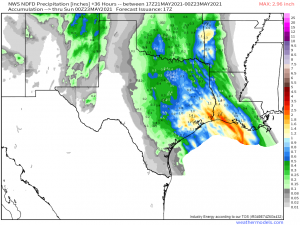
The NWS model paints a rather broad area of at least 1 inch of rain with localized pockets of 2 to 4 inches. Unfortunately, on almost every model, those pockets target the Lake Charles, LA area which just suffered serious flash flooding earlier in the week when they saw 12 inches + of rain in under 6 hours. While another 2 inches doesn’t sound like much, it will be on top of ground that cannot hold any more water. There is also concern for Houston, TX which is prone to flooding and has also received above average rainfall this week.
Breezy conditions at times are likely with the incoming system. Trees in oversaturated ground fall more easily. Any stronger gusts could take out a few trees and possibly also knock out the power.
Like I said, it doesn’t need to be a named storm to cause potentially big problems. If you’re in the SE TX/SW LA region and live in a flood-prone area, now would be a good time to have a plan should flooding threaten your home. Remember to never drive through floodwaters – you never know how deep it is or if the road is washed out underneath. Be safe!
