2020: Breakin’ Records and Takin’ Names
Well, 2020 has done it again.
With the formation of subtropical storm Theta last night, the 2020 Atlantic Hurricane season has produced 29 named storms, toppling 2005’s record 28 named storms. It’s hard to believe that particular record from such an incredible season has fallen. But more on that in a bit. First let’s look into what’s currently going around the nation.
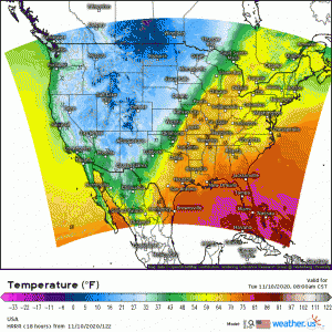
Let’s play “Find the Cold Front”:
(link: https://weather.us/model-charts/rapid-us/usa/temperature-f/20201110-1400z.html)
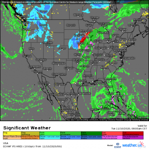
Not that hard to do, right? Currently located over the Great Plains states, it will advance eastward through the day today. Like we talked about yesterday, moisture from Eta, who, by the way, refuses to give up the ghost and dissipate already, is being advected north by the south/southeasterly flow ahead of the front. This is enabling the possibility of heavy rain and storms along and in front of the boundary. Also, a low-level jet is pushing that moisture and warm air behind the front, over top of the cold air, and causing ice and snow issues in parts of the Great Plains and Midwest. If you’re curious about the mechanics of this process, please see Jacob’s blog from yesterday about it here.
So as you can see, a plethora of fun weather is occurring/will occur today and tomorrow thanks to our cold front. I’m watching clouds build in over the mountains as I write this and I gotta say, I’m feeling a little bit like a kid on Christmas morning. Rainy days soothe my soul and I am so tired of the above-average temperatures.
Speaking of which…
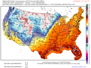
Once again, more records will fall today ahead of the front. Some of these records are extremely long-standing.
For example, here in Knoxville, TN, today’s record high was set well over 100 years ago in 1879 at 78 degrees F. Today’s current forecast high is also 78 degrees F. It’s not much of a stretch to say we have a high chance of breaking or at least tying a record that has stood for 141 years (wow). Thanks, 2020!
This year has been a record breaker all around.
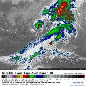
As previously mentioned, Subtropical Storm Theta was named last night
(link: https://weather.us/satellite/368-w-263-n/top-alert-superhd-15min/20201110-1310z.html)
Theta is the 29th named storm of the 2020 Atlantic Hurricane Season, breaking the record of 28 named storms previously held by the 2005 season. This is the first time the name “Theta” has ever been used to name a system. But wait, there’s more! We may soon have a 30th named storm as an area of interest in the Caribbean continues to show signs of organizing. Should it reach tropical storm status, it will be named “Iota”. Bad humor alert: I no longer care one “Iota” about hurricane season.
After ~30 storms this season, I could literally never see a hurricane again and I’d be fine with it. 2020 has been the year that keeps on giving… and I don’t mean that in a positive way.
Some quick stats on the 2005 season vs the 2020 season
2005:
- 28 named storms
- 15 Hurricanes
- 7 Major Hurricanes
2020:
- 29 named storms
- 12 Hurricanes
- 5 Major Hurricanes
As you can see, though 2020 has broken the record for named storms, 2005 still holds the record for most storms that reached hurricane intensity. Also, 1950 holds the record for most major hurricanes with a whopping total of 8. Though I’m tempted to say “we still have a ways to go to break those records,” I won’t. Best not to tempt 2020.
One final thing to address in this blog:
You may have noticed that Theta is classified as a subtropical storm, not a tropical storm. So are they the same thing? In short: no.
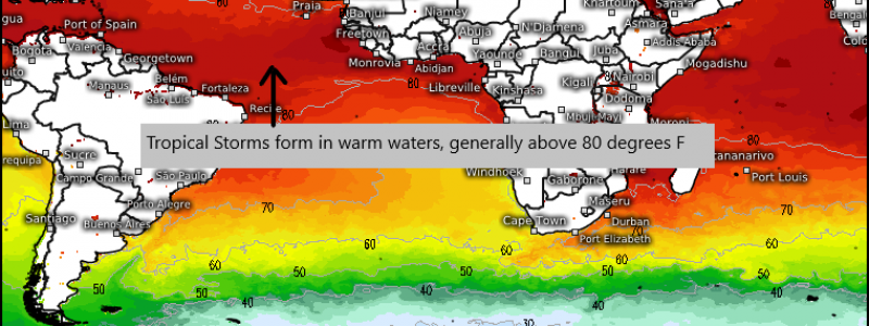
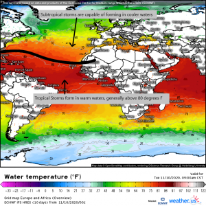
(SST map link: https://weather.us/model-charts/euro/europe-africa/water-temperature-f/20201110-1500z.html)
One of the most important differences, as seen in the graphic above, is that tropical cyclones are known as “warm core” storms and require warm waters above 80 degrees F to initiate cyclogenesis. Warm waters are the fuel which drives a tropical cyclone. These storms do not have temperature and moisture differences within the system. They are warm and saturated throughout. Ocean water evaporates near the storm and then condenses releasing energy back into the atmosphere and driving formation and intensification.
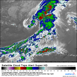
Subtropical cyclones do not require warm waters and can exist in latitudes that tropical cyclones cannot. They are “cold core” storms that generally form from an extratropical system (cold core system associated with a frontal zone, which is why they initially have the appearance of a cold front over the open ocean. See below.)
(link: https://weather.us/satellite/368-w-263-n/top-alert-superhd-15min/20201110-0300z.html)
Reminiscent of a mid-latitude cyclone, isn’t it? A subtropical cyclone has varying temperatures and moisture inside the system. The east side is warmer with higher dew points and more moisture. Refer to the image above; this is where you find the convection. The western side tends to be cooler and generally cloud free – again, like a mid-latitude cyclone. Unlike a tropical system, the thunderstorms are generally found far away from the center of the storm.
Subtropical cyclones are relatively new to the name game. The National Hurricane Center began issuing names for them beginning in 2002.
There are varying opinions regarding the validity of issuing names for subtropical cyclones. Some people don’t believe they should be named during hurricane season since they are not classic, warm core, tropical systems. Regardless of opinions, they do get named and it was a subtropical storm that put the 2020 season over the top to break the record.
Stay tuned to our blog for more information on the ongoing 2020 Hurricane Season, along with your everyday weather happenings.
Have a great day!!


Very interesting!!!