• Velocity Potential: Subseasonal Forecasting Using a Hovmoller Diagram
  • A Little Bit of Mischief in the Gulf
  • Precipitable Water ("PWAT"): What Is It And How Can It Be Used In Forecasting?
  • Cooler, Drier, Wetter, Hotter: A Look at the Upcoming Pattern Flip
  • A Summer Cooldown on Tap for the Northeast & Great Lakes Regions

blog.weather.us

» go to weather.us
» go to weathermodels.com
Menu
  • Home
  • Categories
    • Forecasts and Analysis
    • Weather encyclopedia
    • Noteworthy Weather Events
    • Tutorial Videos
    • Editorials
    • Weathermodels.com
  • Our Authors
    • all posts by Meghan
    • all posts by Armando
    • all posts by Dr. Ryan
    • all posts by Joerg
  • weather.us
    • Forecast Essentials
    • Forecast Light
    • Forecast XL
    • Model Charts
    • Doppler Radar HD
    • Lightning Detection
    • Satellite Images (GOES 16)
    • Precipitation Total
  • weathermodels.com

weather.us Post

Cooler Weather Set To Arrive Over The Eastern US This Week

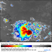
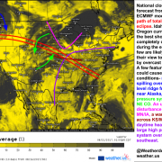
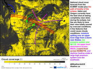
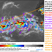
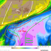
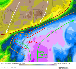
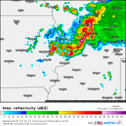
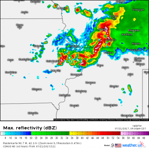
Hello everyone! With the eclipse now behind us, it’s time to look ahead to the upcoming week of weather. The main weather feature in North America will actually develop over …
by Jack Sillin/ 08/21/2017/ No Comments/

Potential Tropical Cyclone 9 Likely To Become TS Harvey This Evening

Hello everyone! I’ve covered some of the marginal severe weather risks on twitter today so the blog will focus on the tropics, where there’s quite a bit of action expected …
by Jack Sillin/ 08/17/2017/ No Comments/

Eclipse 2017 Cloud Cover Forecast

Hello everyone! An unusual and very special atmospheric event is slated to occur on Monday- a total solar eclipse. The path of totality (where the sun is completely obscured by …
by Jack Sillin/ 08/16/2017/ No Comments/

TD8 Recurves East Of The US, 91L May Pose A Larger Threat Long Term

Hello everyone! We’re rapidly approaching the climatological peak of hurricane season and we’re starting to see signs of life in the Atlantic. Last time we talked tropics, Invest 99L was …
by Jack Sillin/ 08/13/2017/ No Comments/

Dangerous Heat Wave Across The Pacific Northwest

Hello everyone! A dangerous heat wave is in the forecast for an unusual part of the country- the Pacific northwest. The region’s normally temperate climate is getting put aside this …
by Jack Sillin/ 08/01/2017/ No Comments/

The Surprise Tropical Storm- TS Emily

Hello everyone! With generally quiet weather today, I’m going to look back on a pretty interesting weather event that took place yesterday. In the span of just a few hours, …
by Jack Sillin/ 08/01/2017/ No Comments/

Mid Atlantic Nor’easter Still Very Much On Track, NYC To Escape The Worst

Hello everyone! Our Mid Atlantic Nor’easter/flooding event is locked and loaded this morning. The “Jackpot” area we discussed yesterday is still on track for some amazing (and very dangerous) rainfall …
by Jack Sillin/ 07/28/2017/ No Comments/

Rare Fujiwhara Interaction Forecast Over The Eastern Pacific

Hello everyone! A rare and beautiful phenomenon is forecast to play out across the remote waters of the Eastern Pacific this weekend and into early next week as two tropical …
by Jack Sillin/ 07/27/2017/ No Comments/

Coastal Storm Set To Bring Heavy Rainfall To The Mid Atlantic Friday Night

Hello everyone! The main weather story today will once again be the unusually powerful coastal storm set to develop tomorrow over the Mid Atlantic. Yesterday, we talked about how much …
by Jack Sillin/ 07/27/2017/ No Comments/

Rare July East Coast Coastal Storm To Develop This Weekend

Hello everyone! Today’s weather is fairly quiet across the country so I’m going to focus on the weather for the weekend, seeing as it is quite fascinating. If you’re looking …
by Jack Sillin/ 07/26/2017/ No Comments/

Severe Storms Target The Northern Plains, Flash Flooding Near Vegas

Hello everyone! There’s rarely if ever a dull moment in the weather across the US and today is no exception. Flash flooding is impacting the Las Vegas area this morning, …
by Jack Sillin/ 07/25/2017/ No Comments/

Coastal Storm To Bring Raw Weather To New England Today

Hello everyone! Today’s weather will be dominated by a feature we would hardly blink at in December, but is notable in July- a weak storm developing off the coast of …
by Jack Sillin/ 07/24/2017/ No Comments/

Strong Storms Expected Across the Upper Midwest Today and Into Tonight

Hello everyone! Another day, another severe weather threat from the northern plains down towards Chicagoland. The NW flow pattern I highlighted a couple of weeks ago continues to crank away …
by Jack Sillin/ 07/21/2017/ No Comments/
  • First
  • Back
  • 37
  • 38
  • 39
  • 40
  • 41
  • Next

Share us

Share on Facebook
Facebook
Tweet about this on Twitter
Twitter
Share on Google+
Google+
Pin on Pinterest
Pinterest
Share on Tumblr
Tumblr
Email this to someone
email

Our authors

Meghan

Armando Salvadore

Armando

Ryan
Dr. Ryan

Joerg
Joerg

Guest author

Jack

John

Tags

2020 Hurricane Season atmospheric river Bermuda High California CAPE coastal storm cold front ensembles EPS fall flooding forecast gusty winds hail heavy rain high pressure hurricane pattern quiet quiet weather rain rapid intensification science severe weather snow spring storm storms summer Swiss Super-HD Model Texas thunderstorm composite thunderstorms tornadoes tropical cyclone tropical storm tropical wave Tropics tutorial uncertainty video weather weather.us weathermodels.com winter

Recent Posts

  • Velocity Potential: Subseasonal Forecasting Using a Hovmoller Diagram
  • A Little Bit of Mischief in the Gulf
  • Precipitable Water (“PWAT”): What Is It And How Can It Be Used In Forecasting?
  • Cooler, Drier, Wetter, Hotter: A Look at the Upcoming Pattern Flip
  • A Summer Cooldown on Tap for the Northeast & Great Lakes Regions

WeatherOK Inc.

  • Omega, OK
    United States
    [email protected]
    Contact

Legal

  • Terms & Conditions

Follow Dr. Ryan

Follow us

Follow weather.us

Copyright © WeatherOK Inc. All rights reserved