In an unfortunately familiar saga for the 2020 hurricane season, Eta is rapidly organizing and intensifying as landfall approaches.
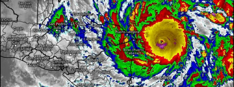
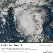
Over the last few hours, the storm has taken advantage of the very warm SSTs, low shear, and favorable atmospheric outflow channels present over the southern Caribbean Sea that I discussed yesterday. A fierce, symmetric CDO with a ring of cloud tops between -75°C and -85°C surrounds a nearly cleared, very small eye, and the NHC recently officially declared the storm’s sustained wind speeds to be 110mph.
Eta looks like a category 3 or 4 hurricane, and is probably not too far from getting there.
Link: https://weather.us/satellite/844-w-160-n/top-alert-superhd-15min/20201102-1540z.html#play-0-12-5
The conditions over the storm look to remain favorable for intensification through landfall. Eta is imbedded in a very moist envelope that spawns much of the Caribbean, as evidenced by broad convection spanning hundreds of miles from the storm’s center. The storm looks to have a healthy outflow band to the north, evidenced by clockwise-moving cirrus clouds stretching in that direction, and another may be developing to the south. And the ocean ahead of Eta is still quite warm, with that warmth stretching to a great depth. Shear looks to increase marginally, but with the moist envelope and the hefty organization, it looks unlikely at the moment that it’ll be able to make a dent in the storm. Really, now that the storm has organized to this extent, it’s all systems go for continued strengthening.
Of course, there is always the shot that an eyewall replacement cycle is able to crush the tiny eye before it reaches land. But time is on Eta’s side,
The only thing looking to stop this storm seems to be land, which is about 20 hours away. In that time, the NHC now forecasts Eta to reach 140mph, a mid-range category 4 intensity. I could see it ending up stronger.
It is of note that this will be among the strongest Atlantic storms for this time of the year, and I believe that the NHC forecast has it behind only 1999 Lenny, 2008 Paloma, and a category 5 hurricane in 1932 for the strongest storm ever so late in the season. Eta, born to break records, continues to be historic.
As the midlevel high I talked about yesterday spills into the Gulf on cue, models remain tightly clustered on an increasing south of west motion for Eta. This will take it on a trajectory to landfall in northeast Nicaragua, likely near Puerto Cabezas.
Eta’s fierce intensity but relatively small size will mean local devastation where it landfalls. A concave coastal shape will help Eta produce 12-18 foot storm surges near the point of landfall, per the NHC. This is a potentially catastrophic inundation, made worse by high background tides with the full moon. Of course, the 140-mph wind itself packed by Eta will also bring devastating impacts close to landfall. As with any small, well organized major hurricane, the damage will be like that of a strong tornado where the eyewall moves ashore. For those close to the landfall location, any preparation should be rushed to completion. This is an extremely dangerous storm.
Landfall will not be the end of Eta’s impacts- rather, a potentially more devastating chapter may begin as the storm slows down over Central America on Tuesday.
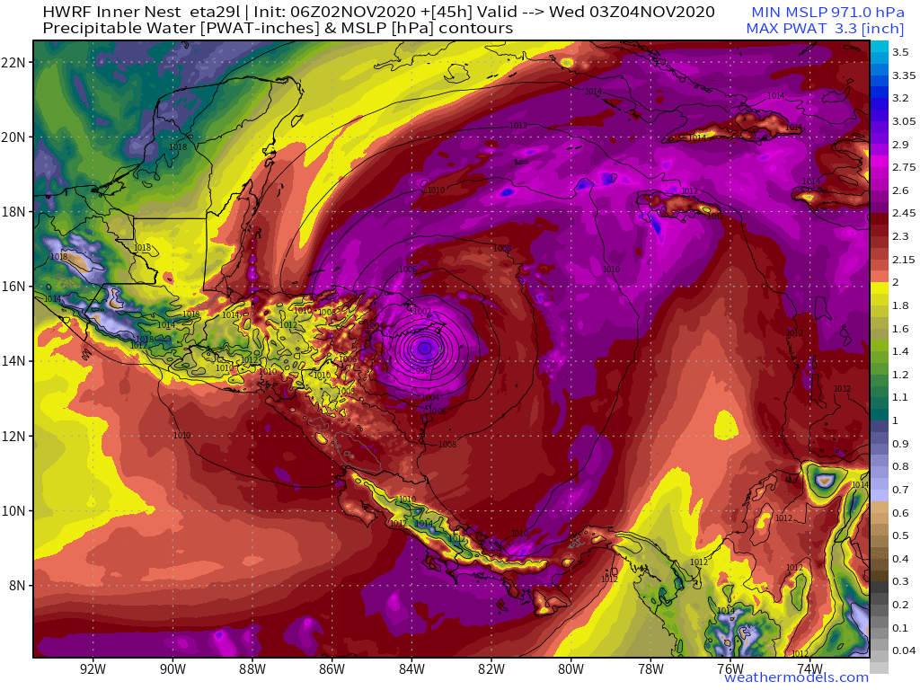
Nicaragua and Honduras are both particularly topographically vulnerable to flash flooding and mudslides from slow moving tropical systems. When Eta meanders slowly over land, a great deal of the same tropical moisture helping the storm strengthen now will continue advecting ashore. This can be seen through HWRF modeled precipitable water, a parameter that indicates how much moisture is present in the atmosphere.
Powerful and moist low level flow like this can create very significant rainfall accumulations over an area if two conditions are met:
The area sees persistent advection of new moisture
The area sees persistent rain-creating convergence
The slow moving Eta will provide both of these conditions for a wide swath of Nicaragua and Honduras over the next few days. Flow itself will be largely constant, with the remnants of the storm’s circulation continuing to advect in deep moisture from the Caribbean. Convergence, too, will be persistent where atmospheric conditions (like feeder bands and the actual cyclone’s center) remain over one area for a while, which seems likely given the slow storm motion. Even more worrying is the ability of mountainous terrain over Central America to act as convergent points for tropical flow. Favored topography like this is probably where we will be seeing 30-40″+ rainfall measurements over the next week, as persistent moist advection hits mountains and is forced to rise and condense.
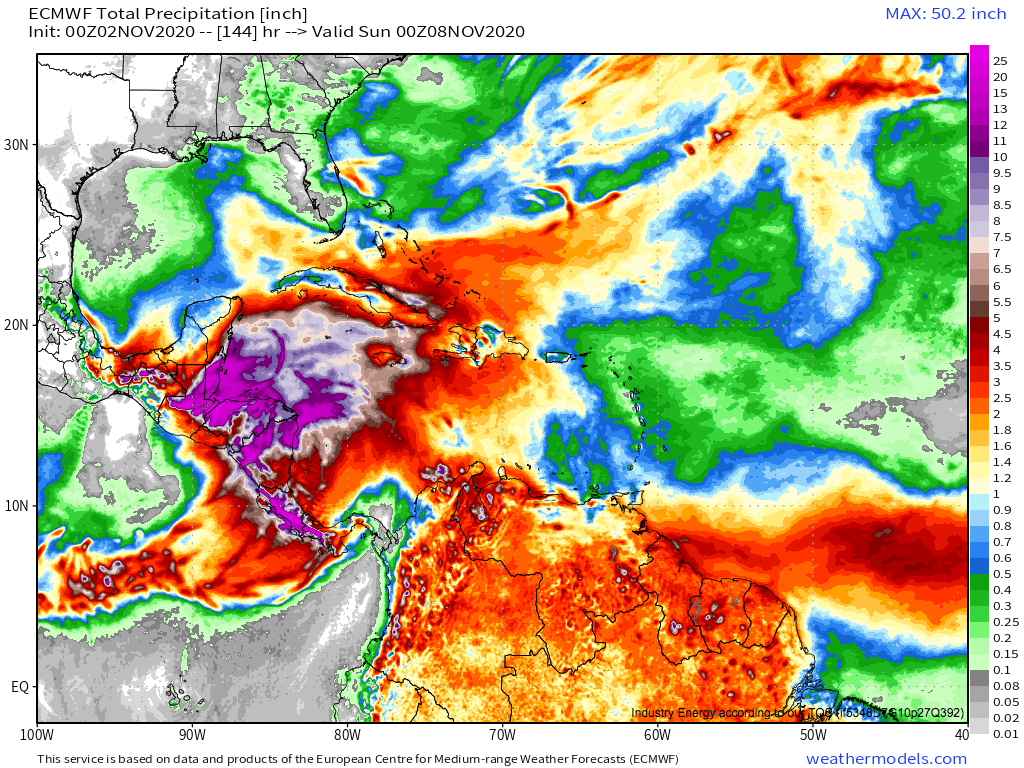
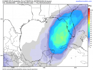
This ECMWF map of modeled rain shows that potential, with a shot at >20″ of rain where there is either favorable topography or persistent atmospheric convergence:
The result will probably be widespread destruction at the hands of both flash floods and mudslides, potentially the worst such disaster to strike the region since Hurricane Mitch killed 19,000 in Honduras and Nicaragua in 1998.
Hurricane Eta is currently rapidly intensifying, and will likely make landfall in northeast Nicaragua at category four intensity early tomorrow with catastrophic impacts from both wind and surge. After landfall, a devastating rain event is possible as persistent, moisture-rich onshore flow meets favorable topography and atmospheric convergence. Eta will be a very significant storm, and those in areas to be affected are encouraged to rush any preparations to completion and to monitor the advise of local governments and the NHC.
We will continue tweeting and blogging about Eta over the next 24 hours.